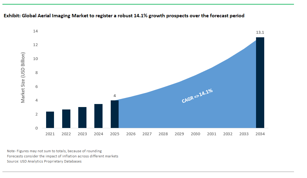
The Global Aerial Imaging Market Size is estimated at $4 Billion in 2025 and is forecast to register an annual growth rate (CAGR) of 14.1% to reach $13.1 Billion by 2034.
The global Aerial Imaging Market Study analyzes and forecasts the market size across 6 regions and 24 countries for diverse segments -By Platform (Fixed-Wing Aircraft, Helicopter, UAV, Others), By Application (Geospatial Mapping, Disaster Management, Energy and Resource Management, Surveillance and Monitoring, Urban Planning, Others), By End-User (Government, Military and Defense, Energy, Agriculture and Forestry, Civil Engineering, Media and Entertainment, Commercial, Others).
An Introduction to Aerial Imaging Market in 2025
The Aerial Imaging is set for robust growth driven by increasing applications in agriculture, urban planning, disaster management, and real estate. Advancements in drone technology, high-resolution cameras, and geographic information systems (GIS) enhance the accuracy and usability of aerial data. The market benefits from rising demand for precision agriculture and environmental monitoring. Challenges include regulatory restrictions and privacy concerns, but innovations like AI-powered image analysis and cloud-based data processing create opportunities. Companies providing real-time imaging and analytics solutions are likely to lead this evolving sector.
Aerial Imaging Competitive Landscape
The market report analyses the leading companies in the industry including Cooper Aerial Surveys Co., Digital Aerial Solutions (DAS) LLC, EagleView Technologies Inc, Fugro, Global UAV Technologies Ltd, Google Inc, Greenman-Pedersen Inc, Kucera International, Landiscor, Nearmap, and others.
Aerial Imaging Market Dynamics
Aerial Imaging Market Trend: Integration of AI and Advanced Analytics
The aerial imaging market is rapidly evolving with the integration of AI and advanced data analytics, transforming raw aerial data into actionable insights. Technologies like computer vision and machine learning enhance image processing, enabling applications in agriculture, urban planning, and disaster management. AI-powered aerial imaging systems improve accuracy in terrain mapping, environmental monitoring, and infrastructure assessment, making them indispensable for data-driven decision-making. This trend not only boosts efficiency but also broadens the market’s capabilities and appeal across industries.
Aerial Imaging Market Driver: Growing Demand for Precision Agriculture and Environmental Monitoring
The increasing need for precision agriculture and effective environmental monitoring is a major driver of the aerial imaging market. Drones and aircraft equipped with high-resolution cameras and multispectral sensors help monitor crop health, optimize irrigation, and manage resources. Similarly, aerial imaging supports environmental conservation by tracking deforestation, water bodies, and climate impact. As sustainable practices gain importance globally, the demand for aerial imaging solutions in these sectors continues to rise.
Aerial Imaging Market Opportunity: Expansion into Infrastructure Development and Smart City Projects
The growth of smart city initiatives and large-scale infrastructure projects presents a significant opportunity for the aerial imaging market. Aerial surveys provide accurate, real-time data for urban planning, construction monitoring, and traffic management. As governments and private developers invest in smarter, more efficient cities, aerial imaging technologies play a crucial role in enhancing project execution and long-term sustainability.
Aerial Imaging Market Share Analysis: Geospatial Mapping is expected to generate the highest revenue in 2025.
The Geospatial Mapping segment is the largest in the Aerial Imaging Market, driven by its widespread use across industries like agriculture, construction, defense, and environmental monitoring. Geospatial mapping relies on high-resolution aerial imagery to create detailed topographical maps, monitor land use, and track changes over time, making it essential for infrastructure development and urban planning. Governments and private sectors heavily invest in geospatial data for decision-making and resource management, ensuring consistent demand. The growing adoption of drones and advanced imaging technologies has made geospatial mapping more cost-effective and accessible, further strengthening its dominance in the market.
Aerial Imaging Market Share Analysis: UAV (Unmanned Aerial Vehicles) is poised to register the fastest growth rate (CAGR) over the forecast period from 2025 to 2034.
The UAV segment is projected to be the fastest growing in the Aerial Imaging Market over the forecast period to 2034, driven by rapid technological advancements, cost efficiency, and versatility. UAVs, or drones, offer high-resolution imaging at a fraction of the cost of traditional aircraft and can access remote or hazardous areas with ease. Their real-time data collection capabilities make them invaluable for surveillance, disaster management, agriculture, and construction monitoring. Additionally, regulatory support and increasing commercial applications are expanding UAV adoption. The miniaturization of powerful cameras, integration of AI-based analytics, and improved battery life further boost the growth potential of this segment.
Aerial Imaging Market Share Analysis: Government is expected to generate the highest revenue in 2025.
The Government segment is the largest in the Aerial Imaging Market, driven by extensive use in geospatial mapping, urban planning, infrastructure development, and disaster management. Governments across the globe rely on aerial imagery for land and resource management, environmental monitoring, and border surveillance. This segment benefits from high-budget allocations for national security, infrastructure projects, and public safety initiatives. Additionally, government agencies collaborate with private firms for advanced aerial surveys and data analytics, further fueling demand. The rising need for accurate topographical data and large-scale monitoring cements the dominance of this segment in the aerial imaging market.
Aerial Imaging Market Report Scope
Aerial Imaging Market
|
Parameter
|
Details
|
|
Market Size (2025)
|
$4 Billion
|
|
Market Size (2034)
|
$13.1 Billion
|
|
Market Growth Rate
|
14.1%
|
|
Segments
|
By Platform (Fixed-Wing Aircraft, Helicopter, UAV, Others), By Application (Geospatial Mapping, Disaster Management, Energy and Resource Management, Surveillance and Monitoring, Urban Planning, Others), By End-User (Government, Military and Defense, Energy, Agriculture and Forestry, Civil Engineering, Media and Entertainment, Commercial, Others)
|
|
Study Period
|
2019- 2024 and 2025-2034
|
|
Units
|
Revenue (USD)
|
|
Qualitative Analysis
|
Porter’s Five Forces, SWOT Profile, Market Share, Scenario Forecasts, Market Ecosystem, Company Ranking, Market Dynamics, Industry Benchmarking
|
|
Companies
|
Cooper Aerial Surveys Co., Digital Aerial Solutions (DAS) LLC, EagleView Technologies Inc, Fugro, Global UAV Technologies Ltd, Google Inc, Greenman-Pedersen Inc, Kucera International, Landiscor, Nearmap
|
|
Countries
|
US, Canada, Mexico, Germany, France, Spain, Italy, UK, Russia, China, India, Japan, South Korea, Australia, South East Asia, Brazil, Argentina, Middle East, Africa
|
Aerial Imaging Market Segmentation
By Platform
Fixed-Wing Aircraft
Helicopter
UAV
Others
By Application
Geospatial Mapping
Disaster Management
Energy and Resource Management
Surveillance and Monitoring
Urban Planning
Others
By End-User
Government
Military and Defense
Energy
Agriculture and Forestry
Civil Engineering
Media and Entertainment
Commercial
Others
Countries Analyzed
North America (US, Canada, Mexico)
Europe (Germany, UK, France, Spain, Italy, Russia, Rest of Europe)
Asia Pacific (China, India, Japan, South Korea, Australia, South East Asia, Rest of Asia)
South America (Brazil, Argentina, Rest of South America)
Middle East and Africa (Saudi Arabia, UAE, Rest of Middle East, South Africa, Egypt, Rest of Africa)
Aerial Imaging Companies Profiled in the Study
Cooper Aerial Surveys Co.
Digital Aerial Solutions (DAS) LLC
EagleView Technologies Inc
Fugro
Global UAV Technologies Ltd
Google Inc
Greenman-Pedersen Inc
Kucera International
Landiscor
Nearmap
*- List Not Exhaustive
About USD Analytics
Table of Contents
List of Charts and Exhibits
List of Tables
1. Executive Summary
What’s New in 2025?
Top 10 Takeaways from the industry
Potential Opportunities for Industry Stakeholders
Strategic Imperatives
Company Market Positioning
Industry Benchmarking Matrix
2. Research Scope and Methodology
Market Definition
- Market Segments
- Companies Profiled
Research Methodology
- Bottom-Up Method
- Top-Down Method
- Data Triangulation
Forecast Methodology
- Data Sources
- USDA Proprietary Databases
- External Sources
- Primary Research and Interviews
Conversion Rates for USD
Abbreviations
3. Strategic Landscape: Key Insights and Implications
Spotlight: Key Strategies opted by Business Leaders
Competitive Landscape
Market Size ($ Million) and Share (%) by Company, 2024
SWOT Analysis
- Key Market Strengths
- Key Market Weaknesses
- Potential Opportunities
- Potential Threats
Porter’s Five Force Analysis
- Summary
- Bargaining Power of Buyers- Impact Analysis
- Bargaining Power of Suppliers- Impact Analysis
- Threat of new entrants- Impact Analysis
- Intensity of Competitive Rivalry- Impact Analysis
Macro-Environmental Analysis
- Economic forecasts by Country, 2010- 2035
- Population forecasts by Country, 2010- 2035
- Inflation Outlook by Country, 2010-2035
- Impact of Russia-Ukraine Conflict, Sluggish China Growth, US Developments
5. Growth Opportunity Analysis
Trends at a Glance
- What are the most noteworthy trends in the market
- Where should leaders pay attention?
- What industries are likely to be affected by the growth?
Market Dynamics
- Charting a path forward
- Growth Drivers
- Growth Barriers
Key Industry Stakeholders
- Suppliers
- Manufacturers and Service Providers
- Distribution Channels
- End-Users and Applications
- Regulators
- Investors, Traders, and R&D Institutes
Regulatory Landscape
6. Market Size Outlook to 2034
Global Aerial Imaging Market Size Forecast, USD Million, 2018- 2034
- Historic Market Size, 2018- 2024
- Forecast Market Size, 2024- 2034
Scenario Analysis
- Low Growth Scenario: Definition and Outlook to 2034
- Reference Case: Definition and Outlook to 2034
- High Growth Scenario: Definition and Outlook to 2034
Pricing Analysis and Outlook
- Aerial Imaging Average Price Forecast, 2021- 2034
- Key Factors Shaping the Pricing Patterns
7. Historical Aerial Imaging Market Size by Segments, 2018- 2024
Key Statistics, 2024
Aerial Imaging Market Size Outlook by Type, USD Million, 2018- 2024
Growth Comparison (y-o-y) across Aerial Imaging Types, 2018- 2024
Aerial Imaging Market Size Outlook by Application, USD Million, 2018- 2024
Growth Comparison (y-o-y) across Aerial Imaging Applications, 2018- 2024
8. Aerial Imaging Market Size Outlook by Segments, 2024- 2034
By Platform
Fixed-Wing Aircraft
Helicopter
UAV
Others
By Application
Geospatial Mapping
Disaster Management
Energy and Resource Management
Surveillance and Monitoring
Urban Planning
Others
By End-User
Government
Military and Defense
Energy
Agriculture and Forestry
Civil Engineering
Media and Entertainment
Commercial
Others
9. Aerial Imaging Market Size Outlook by Region
North America
Key Market Dynamics
North America Aerial Imaging Market Size Outlook by Type, USD Million, 2021-2034
North America Aerial Imaging Market Size Outlook by Application, USD Million, 2021-2034
North America Aerial Imaging Market Size Outlook by Sales Channel, USD Million, 2021-2034
North America Aerial Imaging Market Size Outlook by Country, USD Million, 2021-2034
Europe
Key Market Dynamics
Europe Aerial Imaging Market Size Outlook by Type, USD Million, 2021-2034
Europe Aerial Imaging Market Size Outlook by Application, USD Million, 2021-2034
Europe Aerial Imaging Market Size Outlook by Sales Channel, USD Million, 2021-2034
Europe Aerial Imaging Market Size Outlook by Country, USD Million, 2021-2034
Asia Pacific
Key Market Dynamics
Asia Pacific Aerial Imaging Market Size Outlook by Type, USD Million, 2021-2034
Asia Pacific Aerial Imaging Market Size Outlook by Application, USD Million, 2021-2034
Asia Pacific Aerial Imaging Market Size Outlook by Sales Channel, USD Million, 2021-2034
Asia Pacific Aerial Imaging Market Size Outlook by Country, USD Million, 2021-2034
South America
Key Market Dynamics
South America Aerial Imaging Market Size Outlook by Type, USD Million, 2021-2034
South America Aerial Imaging Market Size Outlook by Application, USD Million, 2021-2034
South America Aerial Imaging Market Size Outlook by Sales Channel, USD Million, 2021-2034
South America Aerial Imaging Market Size Outlook by Country, USD Million, 2021-2034
Middle East and Africa
Key Market Dynamics
Middle East and Africa Aerial Imaging Market Size Outlook by Type, USD Million, 2021-2034
Middle East and Africa Aerial Imaging Market Size Outlook by Application, USD Million, 2021-2034
Middle East and Africa Aerial Imaging Market Size Outlook by Sales Channel, USD Million, 2021-2034
Middle East and Africa Aerial Imaging Market Size Outlook by Country, USD Million, 2021-2034
10. United States Aerial Imaging Market Analysis and Outlook, 2021- 2034
Key Statistics
United States Aerial Imaging Market Size Outlook by Type, 2021- 2034
United States Aerial Imaging Market Size Outlook by Application, 2021- 2034
United States Aerial Imaging Market Size Outlook by End-User, 2021- 2034
11. Canada Aerial Imaging Market Analysis and Outlook, 2021- 2034
Key Statistics
Canada Aerial Imaging Market Size Outlook by Type, 2021- 2034
Canada Aerial Imaging Market Size Outlook by Application, 2021- 2034
Canada Aerial Imaging Market Size Outlook by End-User, 2021- 2034
12. Mexico Aerial Imaging Market Analysis and Outlook, 2021- 2034
Key Statistics
Mexico Aerial Imaging Market Size Outlook by Type, 2021- 2034
Mexico Aerial Imaging Market Size Outlook by Application, 2021- 2034
Mexico Aerial Imaging Market Size Outlook by End-User, 2021- 2034
13. Germany Aerial Imaging Market Analysis and Outlook, 2021- 2034
Key Statistics
Germany Aerial Imaging Market Size Outlook by Type, 2021- 2034
Germany Aerial Imaging Market Size Outlook by Application, 2021- 2034
Germany Aerial Imaging Market Size Outlook by End-User, 2021- 2034
14. France Aerial Imaging Market Analysis and Outlook, 2021- 2034
Key Statistics
France Aerial Imaging Market Size Outlook by Type, 2021- 2034
France Aerial Imaging Market Size Outlook by Application, 2021- 2034
France Aerial Imaging Market Size Outlook by End-User, 2021- 2034
15. United Kingdom Aerial Imaging Market Analysis and Outlook, 2021- 2034
Key Statistics
United Kingdom Aerial Imaging Market Size Outlook by Type, 2021- 2034
United Kingdom Aerial Imaging Market Size Outlook by Application, 2021- 2034
United Kingdom Aerial Imaging Market Size Outlook by End-User, 2021- 2034
16. Spain Aerial Imaging Market Analysis and Outlook, 2021- 2034
Key Statistics
Spain Aerial Imaging Market Size Outlook by Type, 2021- 2034
Spain Aerial Imaging Market Size Outlook by Application, 2021- 2034
Spain Aerial Imaging Market Size Outlook by End-User, 2021- 2034
17. Italy Aerial Imaging Market Analysis and Outlook, 2021- 2034
Key Statistics
Italy Aerial Imaging Market Size Outlook by Type, 2021- 2034
Italy Aerial Imaging Market Size Outlook by Application, 2021- 2034
Italy Aerial Imaging Market Size Outlook by End-User, 2021- 2034
18. Benelux Aerial Imaging Market Analysis and Outlook, 2021- 2034
Key Statistics
Benelux Aerial Imaging Market Size Outlook by Type, 2021- 2034
Benelux Aerial Imaging Market Size Outlook by Application, 2021- 2034
Benelux Aerial Imaging Market Size Outlook by End-User, 2021- 2034
19. Nordic Aerial Imaging Market Analysis and Outlook, 2021- 2034
Key Statistics
Nordic Aerial Imaging Market Size Outlook by Type, 2021- 2034
Nordic Aerial Imaging Market Size Outlook by Application, 2021- 2034
Nordic Aerial Imaging Market Size Outlook by End-User, 2021- 2034
20. Rest of Europe Aerial Imaging Market Analysis and Outlook, 2021- 2034
Key Statistics
Rest of Europe Aerial Imaging Market Size Outlook by Type, 2021- 2034
Rest of Europe Aerial Imaging Market Size Outlook by Application, 2021- 2034
Rest of Europe Aerial Imaging Market Size Outlook by End-User, 2021- 2034
21. China Aerial Imaging Market Analysis and Outlook, 2021- 2034
Key Statistics
China Aerial Imaging Market Size Outlook by Type, 2021- 2034
China Aerial Imaging Market Size Outlook by Application, 2021- 2034
China Aerial Imaging Market Size Outlook by End-User, 2021- 2034
22. India Aerial Imaging Market Analysis and Outlook, 2021- 2034
Key Statistics
India Aerial Imaging Market Size Outlook by Type, 2021- 2034
India Aerial Imaging Market Size Outlook by Application, 2021- 2034
India Aerial Imaging Market Size Outlook by End-User, 2021- 2034
23. Japan Aerial Imaging Market Analysis and Outlook, 2021- 2034
Key Statistics
Japan Aerial Imaging Market Size Outlook by Type, 2021- 2034
Japan Aerial Imaging Market Size Outlook by Application, 2021- 2034
Japan Aerial Imaging Market Size Outlook by End-User, 2021- 2034
24. South Korea Aerial Imaging Market Analysis and Outlook, 2021- 2034
Key Statistics
South Korea Aerial Imaging Market Size Outlook by Type, 2021- 2034
South Korea Aerial Imaging Market Size Outlook by Application, 2021- 2034
South Korea Aerial Imaging Market Size Outlook by End-User, 2021- 2034
25. Australia Aerial Imaging Market Analysis and Outlook, 2021- 2034
Key Statistics
Australia Aerial Imaging Market Size Outlook by Type, 2021- 2034
Australia Aerial Imaging Market Size Outlook by Application, 2021- 2034
Australia Aerial Imaging Market Size Outlook by End-User, 2021- 2034
26. South East Asia Aerial Imaging Market Analysis and Outlook, 2021- 2034
Key Statistics
South East Asia Aerial Imaging Market Size Outlook by Type, 2021- 2034
South East Asia Aerial Imaging Market Size Outlook by Application, 2021- 2034
South East Asia Aerial Imaging Market Size Outlook by End-User, 2021- 2034
27. Rest of Asia Pacific Aerial Imaging Market Analysis and Outlook, 2021- 2034
Key Statistics
Rest of Asia Pacific Aerial Imaging Market Size Outlook by Type, 2021- 2034
Rest of Asia Pacific Aerial Imaging Market Size Outlook by Application, 2021- 2034
Rest of Asia Pacific Aerial Imaging Market Size Outlook by End-User, 2021- 2034
28. Brazil Aerial Imaging Market Analysis and Outlook, 2021- 2034
Key Statistics
Brazil Aerial Imaging Market Size Outlook by Type, 2021- 2034
Brazil Aerial Imaging Market Size Outlook by Application, 2021- 2034
Brazil Aerial Imaging Market Size Outlook by End-User, 2021- 2034
29. Argentina Aerial Imaging Market Analysis and Outlook, 2021- 2034
Key Statistics
Argentina Aerial Imaging Market Size Outlook by Type, 2021- 2034
Argentina Aerial Imaging Market Size Outlook by Application, 2021- 2034
Argentina Aerial Imaging Market Size Outlook by End-User, 2021- 2034
30. Rest of South America Aerial Imaging Market Analysis and Outlook, 2021- 2034
Key Statistics
Rest of South America Aerial Imaging Market Size Outlook by Type, 2021- 2034
Rest of South America Aerial Imaging Market Size Outlook by Application, 2021- 2034
Rest of South America Aerial Imaging Market Size Outlook by End-User, 2021- 2034
31. United Arab Emirates Aerial Imaging Market Analysis and Outlook, 2021- 2034
Key Statistics
United Arab Emirates Aerial Imaging Market Size Outlook by Type, 2021- 2034
United Arab Emirates Aerial Imaging Market Size Outlook by Application, 2021- 2034
United Arab Emirates Aerial Imaging Market Size Outlook by End-User, 2021- 2034
32. Saudi Arabia Aerial Imaging Market Analysis and Outlook, 2021- 2034
Key Statistics
Saudi Arabia Aerial Imaging Market Size Outlook by Type, 2021- 2034
Saudi Arabia Aerial Imaging Market Size Outlook by Application, 2021- 2034
Saudi Arabia Aerial Imaging Market Size Outlook by End-User, 2021- 2034
33. Rest of Middle East Aerial Imaging Market Analysis and Outlook, 2021- 2034
Key Statistics
Rest of Middle East Aerial Imaging Market Size Outlook by Type, 2021- 2034
Rest of Middle East Aerial Imaging Market Size Outlook by Application, 2021- 2034
Rest of Middle East Aerial Imaging Market Size Outlook by End-User, 2021- 2034
34. South Africa Aerial Imaging Market Analysis and Outlook, 2021- 2034
Key Statistics
South Africa Aerial Imaging Market Size Outlook by Type, 2021- 2034
South Africa Aerial Imaging Market Size Outlook by Application, 2021- 2034
South Africa Aerial Imaging Market Size Outlook by End-User, 2021- 2034
35. Rest of Africa Aerial Imaging Market Analysis and Outlook, 2021- 2034
Key Statistics
Rest of Africa Aerial Imaging Market Size Outlook by Type, 2021- 2034
Rest of Africa Aerial Imaging Market Size Outlook by Application, 2021- 2034
Rest of Africa Aerial Imaging Market Size Outlook by End-User, 2021- 2034
36. Key Companies
Market Share Analysis
Cooper Aerial Surveys Co.
Digital Aerial Solutions (DAS) LLC
EagleView Technologies Inc
Fugro
Global UAV Technologies Ltd
Google Inc
Greenman-Pedersen Inc
Kucera International
Landiscor
Nearmap
Company Benchmarking
Financial Analysis
37. Recent Market Developments
38. Appendix
Looking Ahead
Research Methodology
Legal Disclaimer